Man.. I forgot how cool this thread was , there are some kickass pics in here!
You are using an out of date browser. It may not display this or other websites correctly.
You should upgrade or use an alternative browser.
You should upgrade or use an alternative browser.
Fire outlook towers
- Thread starter sirbuildalot
- Start date

Help Support Arborist Forum:
This site may earn a commission from merchant affiliate
links, including eBay, Amazon, and others.
Agreed!
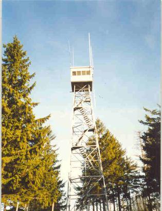
Yes but we call them Forest Fire Lookout towers.Do any of you guys have one of these in your area? I have one about 1.5 miles from my house. They're really pretty interesting structures. Kind of like giant treehouses minus the tree. It seems many were built in the teens and twenties, and suffered fire (ironic) or hurricane damage, and were then rebuilt in the 40's through the 60's.
Heights can vary widely, but 60-68' seems to be a common height. Cab sizes also vary, but 8' x 8', 12' x 12' and 15' x 15' seem pretty common. I know some of the ones out west are much taller. Many have been converted to allow people to spend the night like a hotel. Most are owned by the government, and some are still in active use to this day, as is the case with the one near me. These were used around the world, not just the united states.
This is the one in my area. For those unfamiliar with these structures they were widely used to detect smoke over a wide area. Typically up on a hill or high elevation area of town. 360 degree views with windows, binoculars, and a device called an "Osbourne fire finder", were common features to allow the attendant to alert the station of possible fires.

peakbagger
ArboristSite Member
The US Forest Service had some standard designs and specifications that several firms could supply. There are some PDF copies out on the web. The tower in the photo looks like one of their standard designs despite being in Canada There was a small cab design and a larger cab design as well as a wooden tower designs. The parts are designed to be universally interchangeable to the maximum amount possible. There are also firms that dismantle and sell used towers, they will either sell you a pile of parts or re-erect them. They don't require a crane, they were erected with gin poles and pulleys. Many were built in the Eastern US forests long before helicopters so frequently there was a bull dozer road built with a small bull dozer, some of the old roads are quite impressive how they got up steep terrain to the top of the mountain. Some became hiking trails but many were abandoned.

$38.99 ($0.39 / Foot)
Arborist Rope Climbing Rope Swing for Tree(1/2in x 100ft) Logging Rope 48 Strands for Pull, Swing, Knot (Orange)
SDFJKLDI

$14.97
$19.99
Dremel A679-02 Sharpening Attachment Kit, For Sharpening Outdoor Gardening Tools, Chainsaws, and Home DIY Projects,
Amazon.com

$202.29
Oregon Yukon Chainsaw Safety Protective Bib & Braces Trousers - Type A Protection, Dark Grey, Large
Express Shipping ⭐⭐⭐⭐⭐

$14.99
$17.99
Fiskars Pole Saw Blade Replacement for Fiskars Pruning Saws and Tree Pruners, 15" Blade with Woodzig Chainsaw-Style Tooth Design
AMZ South Supply

$215.05
$233.19
Weaver Leather WLC 315 Saddle with 1" Heavy Duty Coated Webbing Leg Straps, Medium, Brown/Red
Amazon.com

$79.99
ZELARMAN Chainsaw Chaps 8-layer Protective Apron Wrap Adjustable Chainsaw Pants/Chap for Loggers Forest Workers Class A
QUALITY GARDEN & HAND TOOLS

$26.99 ($0.22 / Foot)
$29.99 ($0.25 / Foot)
VEVOR Double Braided Polyester Rope, 1/2 in x 120 ft, 48 Strands, 8000 LBS Breaking Strength Outdoor Rope, Arborist Rigging Rope for Rock Hiking Camping Swing Rappelling Rescue, Orange/Black
Amazon.com

$337.83
$369.99
WEN Electric Log Splitter, 6.5-Ton Capacity with Portable Stand (56208)
Amazon.com

$63.99
ZELARMAN Chainsaw Chaps Apron Wrap 8-layer for Men/Women Loggers Forest Workers Protective Chain Saw Pants Adjustable
QUALITY GARDEN & HAND TOOLS
This is the Bald Mountain lookout tower, near Shaver Lake, California. I think it was last used in the 80s, a 4WD club and the F.S. fixed it up enough to not have to tear it down, several years ago. It’s on a 4WD trail, but there’s a route from Tamarack Ridge that’s easy enough for a stock vehicle. Also a hiking trail from Dinkey Creek road, about a half mile west of Glen Meadow.


Drptrch
Addicted to ArboristSite
I hike with a couple that volunteer at this lookout, also at Park Ridge, and Buck Rock. This is their picture, looking at the Delilah tower from the Kings River near Hermit Hole.
View attachment 810399


Park Ridge during the Rough Fire

And good ole Buck Rock
Sent from my iPhone using Tapatalk
Drptrch
Addicted to ArboristSite
This is the Bald Mountain lookout tower, near Shaver Lake, California. I think it was last used in the 80s, a 4WD club and the F.S. fixed it up enough to not have to tear it down, several years ago. It’s on a 4WD trail, but there’s a route from Tamarack Ridge that’s easy enough for a stock vehicle. Also a hiking trail from Dinkey Creek road, about a half mile west of Glen Meadow.
View attachment 810403

Tobias

Orleans Lookout on the Klamath
Sent from my iPhone using Tapatalk
Drptrch
Addicted to ArboristSite
I hike with a couple that volunteer at this lookout, also at Park Ridge, and Buck Rock. This is their picture, looking at the Delilah tower from the Kings River near Hermit Hole.
View attachment 810399

It’s just to the right of the plume, came down from there and this is from McKenzie Ridge above the Helipad

Sent from my iPhone using Tapatalk
Drptrch
Addicted to ArboristSite

It’s just to the right of the plume, came down from there and this is from McKenzie Ridge above the Helipad

Sent from my iPhone using Tapatalk


As it progressed
Sent from my iPhone using Tapatalk
Nice to have these pictures. I know someone who was on the Rough Fire, but he was up by Spanish Mountain.
Drptrch
Addicted to ArboristSite
Nice to have these pictures. I know someone who was on the Rough Fire, but he was up by Spanish Mountain.
I was detailed to south side of river
Big Meadows to Hume to Converse basin and up to Delilah
Sent from my iPhone using Tapatalk
I was detailed to south side of river
Big Meadows to Hume to Converse basin and up to Delilah
Sent from my iPhone using Tapatalk
My mom was campground host at Stoney Creek, they had to evacuate.
These pictures are of cleaning up the mess on the Spanish OHV trail, and getting it ready to open. It took two seasons, then the hydrologist had to approve it. I volunteer with OHV by the way.


Similar threads
- Replies
- 0
- Views
- 460
- Replies
- 3
- Views
- 2K
- Replies
- 9
- Views
- 1K
- Replies
- 19
- Views
- 2K


