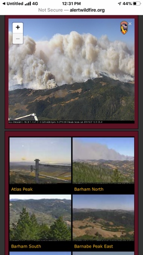
Smoke/wind update heading into the weekend: Possible smoke accumulation Saturday, super-strong northeasterly winds carrying smoke from the
#KincadeFire to the coast on Sunday.
Saturday's winds will be light - a kind of calm before the storm, if you will (see first image). The problem with light winds is that the wind direction becomes very uncertain. For Santa Rosa, depending in the weather model, winds could be northwesterly, northeasterly, or southerly. Obviously, light northerly is the wind direction we're worried about for gradual smoke transport into Healdsburg, Santa Rosa, Rohnert Park, and farther south. Throughout the day Saturday, light winds will allow smoke to accumulate, becoming dense and leading to worse smoke impacts near the fire. Whether Santa Rosa gets hammered with that dense smoke will depend on what direction the winds take, and it may change throughout the day. Possibly making matter worse, after high temperatures in the low-90s today, temps will drop into the 40s tonight, producing a strong temperature inversion and trapping smoke near the ground again. Check
AirNow.gov or
PurpleAir.com (recommend using the LRAPA conversion) for local conditions. If it's over 100 AQI, or if you see or smell smoke, stay indoors if possible, or at least reduce outdoor activity.
Sunday is another story altogether. We're looking at possibly the strongest wind event in the last 10 years, with sustained winds around 20-25 mph developing early in the morning (second image), and gusts over 50 mph (even stronger over higher terrain). The wind direction will generally be northeasterly, with variations from east-northeasterly to north-northeasterly. The result will be smoke transport to the southwest of the fire, just to the north of Guerneville, towards Jenner, and off the coast.
Important detail: I'm talking about transport of *new* smoke, directly from the fire. If, for instance, there's gradual smoke transport to the south on Saturday (into Santa Rosa and farther south), the northeasterly winds will carry that smoke into Sebastopol and other communities to the west.
Obviously, with strong offshore winds and very low humidity, fire danger will be high on Sunday into Monday. Stay safe.


